Franklin County Engineer Facebook Feed

Franklin County Engineer

As a local public works agency headquartered in Columbus, Ohio, the Franklin County Engineer's Office is responsible for the maintenance and construction of 271 miles of county roadway and 351 county bridges, as well as upkeep of all county ditches, drains, retention basins, and other storm water facilities within the right-of-way of county roads in unincorporated areas. To meet the continuing development and infrastructure needs of Franklin County, the Engineer's Office utilizes the latest technologies for determining and maintaining roadway centerlines and boundaries; retracing and setting new monuments for original public land surveys; preparing geographic information system mapping for real estate tax assessments; and establishing precise countywide horizontal and vertical control to maintain uniformity in construction, surveying, and mapping.
Franklin County Engineer
This morning, Engineer Fowler and #TeamFCEO hosted our Intern and Summer Help Networking Event where participants had the opportunity to connect with one another and hear from FCEO staff as they shared their diverse career paths, including a wide range of disciplines and professional experiences prior to joining FCEO. It was a valuable morning of learning, conversation, and inspiration. We’re proud to invest in the next generation entering the workforce as they explore meaningful and rewarding career paths.
Franklin County Engineer
The Franklin County Fair kicks off Monday, July 14, 2025. Join us on opening day for County Engineer Adam W. Fowler Day! Bring your family and friends to celebrate, help us paint a snowplow, and enjoy hands-on fun for all ages. We can’t wait to see you there!
Franklin County Engineer
Beach Road, west of Amity Road, is closed for bridge maintenance work. The closure will last approximately ninety (90) days, weather permitting.
Franklin County Engineer
Harrisburg-Georgesville Road over Big Darby Creek, between London-Groveport Road and Opossum Run Road, is closed for bridge rehabilitation work. The closure will last approximately one-hundred eighty (180) days, weather permitting.
Franklin County Engineer
Eiterman Road over South Fork Indian Run, between Post Road and Bobcat Way, will be closed beginning Monday, July 14, 2025, to replace and widen the existing bridge to accommodate the future build-out of the Dublin throughfare plan. The closure will last approximately ninety (90) days, weather permitting.
Franklin County Engineer
Winchester Pike over Coble & Bowman Ditch, between Shannon Road and Bachman Road, will be closed beginning Monday, July 14, 2025, to widen the roadway and replace the existing culvert. The closure will last approximately sixty (60) days, weather permitting.
Franklin County Engineer's Office
970 DUBLIN ROAD
COLUMBUS, OHIO 43215
(614) 525-3030
fracoeng@franklincountyengineer.org

Follow Us

Top
 

Highway Chronicle Chapter 2

Highway Chronicle Chapter 2

Columbus is Established as New Ohio Capital

map

Chillicothe and Zanesville served as the provisional capitals of Ohio until February 14, 1812 when the state legislature chose native forest on the high bank of the Scioto River, across from the settlement of Franklinton, to become the new capital. Architect Joel Wright and Franklin County Surveyor Joseph Vance were assigned the task of surveying and laying out a new town that reflected the popular urban designs of Colonial America.

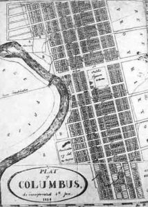
The principle thoroughfares were set to cross each other at right angles with High Street, the major north-south route, bearing 12 degrees west of north, and Broad Street, the major east-west route, 12 degrees north of east. The exact reason for the city’s positioning remains unknown, but one theory suggests that the city is skewed 12 degrees to line up with the streets of Franklinton. Another consideration is the fact that at the time the difference between True North and Magnetic North was 12 degrees. A plat of the town not corrected for the difference would, in fact, skew 12 degrees west of north (shown here).

The other original north-south roads, from west to east, were West Street, Water Street, Third Street, Fourth Street, Seventh Street, and Meadow Lane. East-West Roads, north to south, included Last Street, North Street, Spring Street, Long Street, Gay Street, State Street, Town Street, Rich Street, Friend Street, South Street, and Public Lane.

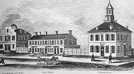
The widest of these boulevards, surpassing the typical road width of 82.5 feet, were Broad Street (120 feet) and High Street (100 feet) that were envisioned as major arteries for travel and commerce leading to Capital Square (shown here) .

In 1816, Ohio government established permanent residence in its newly formed crossroads home.

building