Franklin County Engineer Facebook Feed

Franklin County Engineer

As a local public works agency headquartered in Columbus, Ohio, the Franklin County Engineer's Office is responsible for the maintenance and construction of 271 miles of county roadway and 351 county bridges, as well as upkeep of all county ditches, drains, retention basins, and other storm water facilities within the right-of-way of county roads in unincorporated areas. To meet the continuing development and infrastructure needs of Franklin County, the Engineer's Office utilizes the latest technologies for determining and maintaining roadway centerlines and boundaries; retracing and setting new monuments for original public land surveys; preparing geographic information system mapping for real estate tax assessments; and establishing precise countywide horizontal and vertical control to maintain uniformity in construction, surveying, and mapping.
Franklin County Engineer
Morse Road between the county line and Babbitt Road is now open to traffic.
Franklin County Engineer
Today is #EarthDay2024, and this year's theme is “Planet vs. Plastics”. Take a moment to think about how you and your family can live more environmentally friendly. Please remember to be kind to our planet because its sustainability is in our hands.

Visit https://www.earthday.org/ to learn more.
Franklin County Engineer
#TeamFCEO participated in the Hilliard/Ray Patch Family YMCA’s “Healthy Kids Day” where we had a lot of fun showcasing our snowplow mounted truck and interacting with the attendees. To learn more, visit https://www.ymca.org/what-we-do/healthy-living/family-time/healthy-kids-day.
Franklin County Engineer
Lockbourne Road at London-Groveport Road (SR 317) is now open to traffic.
Franklin County Engineer's Office
970 DUBLIN ROAD
COLUMBUS, OHIO 43215
(614) 525-3030
fracoeng@franklincountyengineer.org
Top
 

Highway Chronicle Chapter 11

Highway Chronicle Chapter 11

Post-War Road Construction Boom Shapes the Way We Travel

map

World War II focused new emphasis on the importance of roads as military supply and evacuation routes.

President Roosevelt signed the Federal-Aid Highway Act of 1944 authorizing the creation of a “National System of Interstate Highways,” but this initiative would remain under-funded until President Eisenhower signed the Federal-Aid Highway Act of 1956. This legislation provided for one of America’s largest public works programs, which was the construction of our multi-lane interstate highway system, and the modernization of state and local routes.

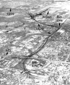
Interstate highways eventually built through Franklin County include I-70 (1962), I-71 (1966), I-270 (1976), and I-670 (2003).

Major federal and state routes include Broad Street (S.R. 16 & U.S. 40), Cleveland Avenue/Westerville Road (S.R. 3), Dublin-Granville Road (S.R. 161), Hamilton Road (S.R. 317), Harrisburg Pike (S.R. 3 & U.S. 62), High Street/Indianola Avenue/Portsmouth-Columbus Road (U.S. 23), Jackson Pike (S.R. 104), Johnstown Road (U.S. 62), London-Groveport Road (S.R. 665), Main Street (U.S. 40), Riverside Drive/Livingston Avenue/Columbus-Lancaster Road (U.S. 33), and State Route 315.