Our Team
Meet the Franklin County Engineer’s Office
Departments
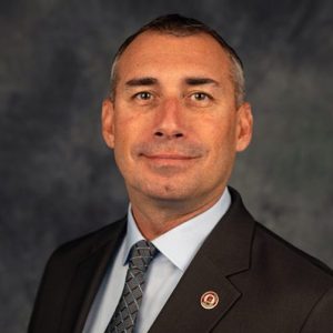
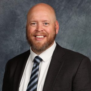
County Engineer
Adam W. Fowler, P.E., P.S.
- Focuses on improving the safety and quality of the Franklin County transportation system
- Works closely with other county elected officials and administration on transportation and drainage-related issues
- Supports the agency’s collaborative mission by building strong relationships with key partners, including local municipalities, industry professionals, the residents of Franklin County, and the traveling public
COUNTY ENGINEER
Adam W. Fowler
P.E., P.S.
 Executive Assistant
Elizabeth Kuhn
- Prepares resolutions, memos, and letters for the County Engineer and Chief Deputies
- Provides information and data to state and local authorities
- Serves as liaison between County Engineer and upper management and coordinates communication between departments
EXECUTIVE ASSISTANT
Elizabeth Kuhn
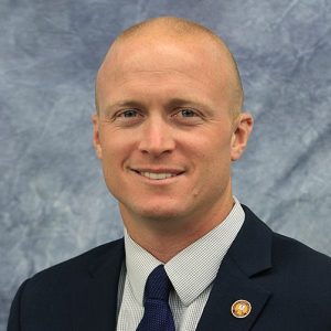
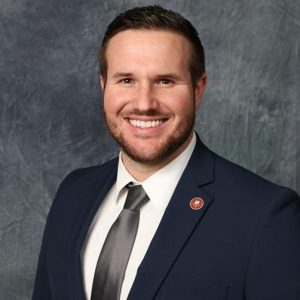
Chief Deputy of Engineering
Wm. Fritz Crosier, P.E.
- Oversees and manages all engineering functions
- Assists the County Engineer with project priorities, construction plan approvals, and purchases
- Monitors progress on projects and maintains compliance with local, state, and federal guidelines
CHIEF DEPUTY OF ENGINEERING
Wm. Fritz Crosier
P.E.
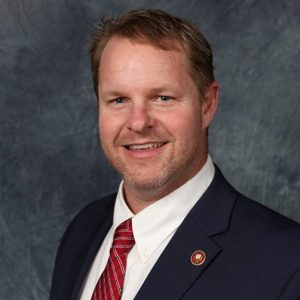
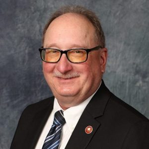
Chief Deputy of Operations
Brad Foster, P.E., P.S.
- Manages all aspects of the Construction Services, Surveying, Tax Map, Highway Maintenance, Fleet Maintenance, and Building & Grounds Maintenance Departments, ensuring efficient and effective operations
- Assists the County Engineer with project priorities, construction plan approvals, and purchases
- Monitors progress on projects and maintains compliance with local, state, and federal guidelines
CHIEF DEPUTY OF OPERATIONS
Brad Foster
P.E., P.S.
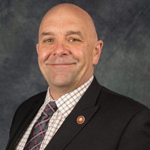
Chief Maintenance Officer
Matt Balster
- Provides for the safe and efficient operation of county roadways, including oversight of maintenance activities such as pavement and berm repair, drainage improvements, roadside mowing, tree trimming, and debris removal.
- Leads road and highway operations, including snow and ice response, snow fence installation, and coordination of FCEO Snow Fighters to maintain safe and accessible travel during inclement weather.
- Manages fleet, facilities, and operational assets, including equipment procurement, maintenance, and lifecycle strategies to ensure reliability, cost-effectiveness, and overall operational efficiency.
CHIEF MAINTENANCE OFFICER
Matt Balster
Chief Financial Officer
Brent Welch
- Manages the financial actions of the Franklin County Engineer’s Office
- Develops and manages the budget
- Oversees all accounts receivable/payable items, competitive bidding, and audit reviews
CHIEF FINANCIAL OFFICER
Brent Welch

Director of Human Resources
Dana Bushong
- Oversees and manages all personnel functions
- Develops and administers personnel policies and procedures and maintains compliance with regulatory requirements
- Coordinates with departments to meet staffing needs and oversees payroll, benefits, and performance evaluations
DIRECTOR OF HUMAN RESOURCES
Dana Bushong

Government Affairs Liaison
Nick Soulas
- Provides legal advice, develops strategies, drafts proposals, prepares reports and presentations, and serves as the media contact for legal matters
- Performs research, drafts and reviews contracts/agreements/correspondence, advises on potential legal ramifications of policies and procedures, and ensures the protection of the FCEO’s rights in external interactions
- Delivers presentations for training or professional development and attends public meetings on behalf of the FCEO
GOVERNMENT AFFAIRS LIAISON
Nick Soulas
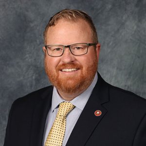
 First Responder Liaison
Greg Thomas
- Maintains communication with law enforcement, fire, EMS, and school districts, providing timely updates on construction projects, road closures, and detours.
- Collects and analyzes traffic crash data, including all fatal crashes on county roadways, and assists with the Weight Enforcement Program in coordination with the Franklin County Sheriff’s Office.
- Represents the Engineer’s Office on regional committees and interagency meetings, while supporting the Mobility Department and other internal teams as needed.
FIRST RESPONDER LIAISON
Greg Thomas
Asset Management
Mark Williams
- Evaluates and monitors infrastructure assets to support effective management for both the Engineer and Drainage Engineer.
- Leads data governance and cost accounting efforts, helping departments make data-driven, cost-effective decisions.
- Audits data and workflows to identify inconsistencies, establish best practices, and provide ongoing training and system improvements.
ASSET MANAGEMENT
Mark Williams

Bridge
Ed Herrick III
- Provides a variety of engineering and maintenance services to ensure the safety and structural integrity of the county’s bridges and culverts
- Oversees bridge and culvert inventory, inspection, design, and cost estimates
- Manages the bridge and culvert maintenance program which includes general repairs, debris removal, and structural replacement
BRIDGE
Ed Herrick III
P.E.
 Building & Grounds Maintenance
Mike Maggard
- Maintains and repairs all county-owned facilities to ensure safe, functional, and well-kept work environments.
- Oversees upkeep of interior spaces, including offices, fleet maintenance areas, restrooms, and common areas.
- Manages exterior operations through the Grounds team, including landscaping, mowing, and event setup such as the Franklin County Fair.
BUILDING & GROUNDS MAINTENANCE
Mike Maggard

Communications
Carla Marable
- Oversees and manages external communications
- Coordinates public information, digital communications, and media relations
- Creates public awareness for the various projects, events, and duties of the Franklin County Engineer’s Office
COMMUNICATIONS
Carla Marable

Construction Services
Michael Rehfus, Jr., P.E., S.I.
- Administers the construction and inspection services of the road and bridge Capital Improvement Program (CIP) and resurfacing program
- Monitors project safety, expenses, schedules, and personnel
- Implements quality controls and ensures compliance with design plans, specifications, and regulations
CONSTRUCTION SERVICES
Michael Rehfus Jr.
P.E., S.I.

Diversity & Outreach
Simone Burley
- Oversees diversity, outreach, and engagement activities
- Coordinates internal and external engagement to promote diverse and equitable initiatives
- Manages the Antiracism and Equity Program, the Equitable Business Enterprise Program for Locally Funded Projects, and the Employee Investment Program
DIVERSITY & OUTREACH
Simone Burley

Drainage
Jim Ramsey, P.E.
- Oversees the rehabilitation and maintenance of the County’s regional drainage systems and Drainage Maintenance Petition program
- Manages the design, construction, and improvement of ditches, drains, retention basins, and other watercourses within the public right of way
- Coordinates and facilitates the County’s stormwater-related environmental compliance
DRAINAGE
Jim Ramsey
P.E.
Fleet Maintenance
Jordan Davidson
- Ensures county personnel have safe, reliable vehicles and equipment to support the maintenance of Franklin County’s roadways, bridges, and drainage systems
- Manages fuel, service, and repairs for county departments and partner agencies while maintaining cost-effective, efficient operations
- Uses advanced asset management and GPS technology to monitor fleet performance, enhance safety, reduce fuel use, and extend the lifecycle of county equipment
FLEET MAINTENANCE
Jordan Davidson
 GIS
GIS
Ben McCown
- Coordinates and supports GIS activities across the agency, ensuring effective use of geospatial data.
- Manages the creation, maintenance, and sharing of geospatial information with internal teams and external partners.
- Produces key mapping resources, including the Franklin County roadmap and atlas, to provide accurate and comprehensive geographic intelligence.
GIS
Ben McCown

Highway Design
Matthew Rehfus, P.E., S.I.
- Provides engineering design solutions that improve the safety and capacity of roadways and intersections
- Strives to create a durable and integrated highway system that prioritizes safety, efficiency, and prosperity for all road users
- Oversees the Utilities Department
HIGHWAY DESIGN
Matthew Rehfus
P.E., S.I.
 Information Systems
Val Eskin
- Delivers technology solutions and support that empower departments across the agency to operate efficiently and effectively.
- Manages the planning, design, implementation, and maintenance of all information systems and technologies.
- Provides comprehensive IT support—including network, communications, hardware, and user services—across all office locations and field operations.
INFORMATION SYSTEMS
Val Eskin

Mobility Department
Mike Andrako, P.E.
- Works to provide safe and accommodating mobility options for residents of Franklin County utilizing multiple modes of transportation
- Manages the design, installation, and operation of detour routing and traffic control devices, such as pavement striping, traffic signals, guardrails, road signage and school zone flashers
- Designs and administers traffic studies to determine speed limit reductions and traffic calming treatments
MOBILITY DEPARTMENT
Mike Andrako
P.E.
 Planning & Programming
Barb Cox
- Manages the County’s Capital Improvement Plan (CIP), overseeing projects from initial concept through construction.
- Collaborates with agencies and local partners to identify infrastructure needs, prioritize projects, and secure state and federal funding.
- Coordinates project delivery, including consultant selection, schedule and budget oversight, and real estate acquisition for construction.
Planning & Programming
Barb Cox
P.E.
 Real Estate
Jack Hughes
- Acquires the right of way needed for county road, bridge, and drainage improvement projects
- Oversees and manages land appraisals, acquisitions, and appropriation cases
- Works with the Board of County Commissioners to provide other real estate services
REAL ESTATE
Jack Hughes
 Safety
Greg Hughes
- Promotes a safe and healthy work environment by identifying hazards, implementing safety protocols, and ensuring compliance with all regulations.
- Investigates workplace and vehicular incidents to determine root causes and prevent future occurrences through data analysis and continuous improvement.
- Conducts inspections, audits, and comprehensive training programs while developing emergency response plans to protect employees, customers, and the public.
SAFETY
Greg Hughes
 Safety
Tanner Zarbaugh
- Promotes a safe and healthy work environment by identifying hazards, implementing safety protocols, and ensuring compliance with all regulations.
- Investigates workplace and vehicular incidents to determine root causes and prevent future occurrences through data analysis and continuous improvement.
- Conducts inspections, audits, and comprehensive training programs while developing emergency response plans to protect employees, customers, and the public.
SAFETY
Tanner Zarbaugh
 Security
Brandon Flynn
- Manages daily building access for staff and visitors, ensuring a secure and controlled environment.
- Serves as the first point of contact for emergency roadway maintenance requests and after-hours operations.
- Operates the 24/7 emergency maintenance line, supporting critical response efforts including snow and ice removal.
SECURITY
Brandon Flynn

Surveying & Mapping
Tony Rettke, P.S.
- Performs a variety of surveys to meet the development and infrastructure needs of Franklin County
- Maintains an accurate set of maps and historical records displaying property boundaries, ownership, transfers, parcels, etc.
- Manages the review of legal documents such as deed descriptions and subdivision plats to ensure they meet the Minimum Standards for Boundary Surveys in the State of Ohio and the Franklin County Conveyance Standards
SURVEYING & MAPPING
Tony Rettke
P.S.

Utilities
Elizabeth Pyles
- Oversees the installation and relocation of utilities within the right of way of county roads
- Administers the issuance of special hauling permits for oversized vehicles and right-of-way permits
- Oversees the inspection of subdivision infrastructure for county street compliance within the townships and all privately funded projects within our right of way